
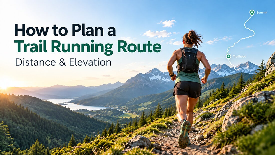
Planning a trail running route is about more than choosing a distance and heading out. Unlike a flat road run, a trail route can include steep climbs, technical descents, uneven terrain, remote sections and significant changes in elevation.
A 15 km trail run with 800 metres of climbing can feel completely different from a flat 15 km road run, which is why it is worth looking at the whole route before you start.
Using a trail running route planner such as Map My Distance allows you to map your route in advance, measure the total distance, check the elevation profile and adjust your course before heading out.
Whether you are planning a short weekend run, exploring a new trail network or training for an upcoming race, a little preparation can make your run much more enjoyable.
Here is how to plan a trail running route step by step.
Decide What Kind of Trail Run You Want
Before placing points on a map, think about what you want from the run.
Are you planning:
- An easy trail run?
- A long weekend run?
- A high-elevation training session?
- A race-specific training route?
- A scenic run in a new area?
- A short route with one large climb?
- A long route with rolling terrain?
Your goal should influence the distance, elevation and terrain you choose.
For example, if you are preparing for a mountainous trail race, a route containing long climbs and descents may be more useful than a longer route with very little elevation.
If you are recovering or simply exploring, you may prefer a shorter and less demanding course.
Choose Your Starting Point
Once you know what kind of run you want, choose where the route will start.
This might be:
- Your home
- A trailhead
- A parking area
- A park
- A race venue
- A campsite
- A familiar landmark
Open your preferred area in the Map My Distance Running Route Planner and place your starting point on the map.
If you are exploring somewhere unfamiliar, spend a little time looking at the surrounding roads, paths and terrain before building the rest of the route.
Choose Between a Loop, Out-and-Back or Point-to-Point Route
The shape of your route can make a big difference to the experience.
Loop Route
A loop starts and finishes in roughly the same place without retracing most of the course.
Loops are great for trail running because they allow you to explore more terrain while returning to your starting point.
Out-and-Back Route
An out-and-back follows the same general route out and back.
This can be useful when exploring unfamiliar trails because you can turn around early if needed.
It is also easy to adjust the total distance.
If you want a 20 km run, for example, you can usually turn around at approximately 10 km.
Point-to-Point Route
A point-to-point route starts and finishes in different locations.
These can be excellent for longer adventures but usually require more planning because you need transport at one or both ends.
Build Your Trail Running Route on the Map
Now you can start creating the actual route.
Place points along the roads, paths or trails you want to use. Map My Distance can connect these points to create the route between them.
Continue adding waypoints until the route follows the area you want to explore.
Do not worry if the distance is not perfect immediately. It is normally easier to create the general shape of the route first and then make small adjustments afterward.
You can add, remove or move points until the course follows the route you want.
Check the Total Distance
Distance is one of the first things most runners look at when planning a route, but trail distance needs to be considered alongside elevation and terrain.
A flat 20 km run can be very different from a 20 km mountain route.
As you build your trail running route, Map My Distance calculates the total distance so you can see how long the route is becoming, and you can also use the pace calculator on the map to calculate running time and pace.
You can then adjust your course to suit your target.
For example:
- 5–10 km for a shorter trail run
- 10–20 km for a moderate training run
- 20–30 km for a long trail run
- 30 km+ for longer-distance or ultra training
There is no single correct distance.
Choose something appropriate for your experience, fitness and the difficulty of the terrain.
Check the Elevation Profile
Elevation is one of the most important parts of planning a trail running route.
Two routes with exactly the same distance can require very different levels of effort depending on how much climbing and descending they contain.
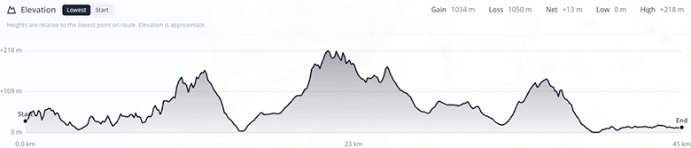
An elevation profile lets you see how the route rises and falls from start to finish.
Before choosing your route, look for:
- Total elevation gain
- Long climbs
- Steep sections
- Major descents
- The highest point on the route
- Where the hardest climbs occur
Map My Distance provides an elevation profile for your planned route, allowing you to understand the shape of the course before you run it.
This is particularly useful when training for trail races where elevation can be just as important as total distance.
How Much Elevation Should a Trail Running Route Have?
There is no ideal amount of elevation for every trail run.
The right amount depends on what you are training for and how experienced you are with climbing.
For an easier session, you may deliberately choose a route with less elevation.
For hill training or preparation for a mountainous event, you might look for significantly more climbing.
The key is to compare both distance and elevation rather than judging the difficulty of a route by kilometres or miles alone.
For example:
15 km with 200 m of climbing may feel relatively runnable.
15 km with 1,000 m of climbing can be a very demanding mountain run.
The terrain, gradient, altitude and trail conditions can also affect how difficult the route feels.
Consider the Terrain
Elevation is not the only thing that affects difficulty.
Trail surfaces can vary dramatically.
A route might include:
- Wide dirt tracks
- Smooth singletrack
- Rocky trails
- Sand
- Mud
- Forest paths
- Mountain paths
- Gravel roads
- Short road sections
Technical terrain will usually slow you down compared with smooth trails or roads.
When planning somewhere unfamiliar, research the area and avoid assuming that a trail shown on a map will necessarily be easy or suitable for running.
Your planned route gives you the structure, but local trail information and current conditions are still important.
Add Useful Points of Interest
For longer trail runs, it can help to identify important locations before you leave.
Depending on the route, these might include:
- Water points
- Toilets
- Parking areas
- Trailheads
- Viewpoints
- Shelters
- Shops
- Cafés
- Major intersections
- Start and finish locations
Map My Distance allows you to add points of interest to routes, which can help you keep important locations associated with your route.
This becomes particularly useful when planning longer adventures or routes in areas you do not know well.
Think About Water, Weather and Conditions
Trail running can take you much further away from roads, buildings and easy access to water than a normal road run.
Before heading out, check the expected conditions for the area.
Consider:
- How long you expect the run to take
- How much water you may need
- Whether water is available along the route
- Temperature
- Wind
- Rain
- Exposure
- Trail conditions
- How quickly conditions could change
Mountain environments in particular can change quickly, so a route that looks straightforward on a map may require more preparation in poor weather.
Plan an Alternative or Shorter Option
It is useful to know where you can shorten your run if things do not go according to plan.
While building the route, look for places where you could:
- Turn around
- Take a shorter trail
- Return to your starting point
- Reach a road or accessible area
This is especially useful on long routes.
You may never need the alternative, but knowing where your options are makes route planning more flexible.
How to Plan a Trail Running Route for Race Training
If you are training for a trail race, your planned routes can help you prepare for the specific demands of the event.
Start by looking at the race’s:
- Distance
- Total elevation gain
- Length of major climbs
- Overall terrain
- Highest elevation
- General route profile
You can then create training routes with similar characteristics.
For example, if you are preparing for a 50 km trail race with substantial climbing, your training does not necessarily need to reproduce the full race route.
Instead, you might create shorter routes that include similar climbs, descents and elevation gain.
As the event gets closer, you can gradually increase the distance or climbing depending on your training plan.
This is one of the biggest advantages of planning routes in advance: you can deliberately choose terrain that matches what you are preparing for instead of simply running the same local loop every week.
Save Your Route Before You Run
Once you are happy with your planned route, save it so you can return to it later.
Saving routes is useful because you can:
- Reuse favourite trail runs
- Make changes later
- Organize training routes
- Compare different options
- Share routes with other runners
- Keep routes for future trips
- Build a collection of places you want to explore
You can also share your Map My Distance route with someone else so they can see where you are planning to run.
Start Planning Your Next Trail Run
A good trail running route combines the right distance, elevation and terrain for the kind of run you want to do.
Instead of choosing a route based only on kilometres or miles, look at the complete course before heading out.
With Map My Distance, you can plan your trail running route online, measure the distance, view the elevation profile, add useful points of interest and adjust the route until it suits your goals.
Whether you are exploring somewhere new or training for your next trail race, planning the route beforehand can help you understand what lies ahead.
Ready to create your next trail route?
Use the Map My Distance Running Route Planner to map your run, check the distance and elevation, and build your next adventure.
Map My Distance can also be used as:
Walking Route Planner
Hiking Route Planner
Cycling Route Planner